Chambly Canal Walking Path: A Local Resident's Guide to the Best Routes

What Makes the Chambly Canal Walking Path Worth Exploring?
The Chambly Canal walking path offers some of the most accessible and scenic routes in our community — flat terrain, waterfront views, and connections to key neighborhoods that make it a practical choice for daily exercise, dog walking, or simply getting outside. Whether you're new to the area or have lived here for years, this guide covers the best segments, where to park, what to expect seasonally, and how to link your walk with other local amenities. No need to drive to Montreal for a decent stroll — Chambly has everything you need right here.
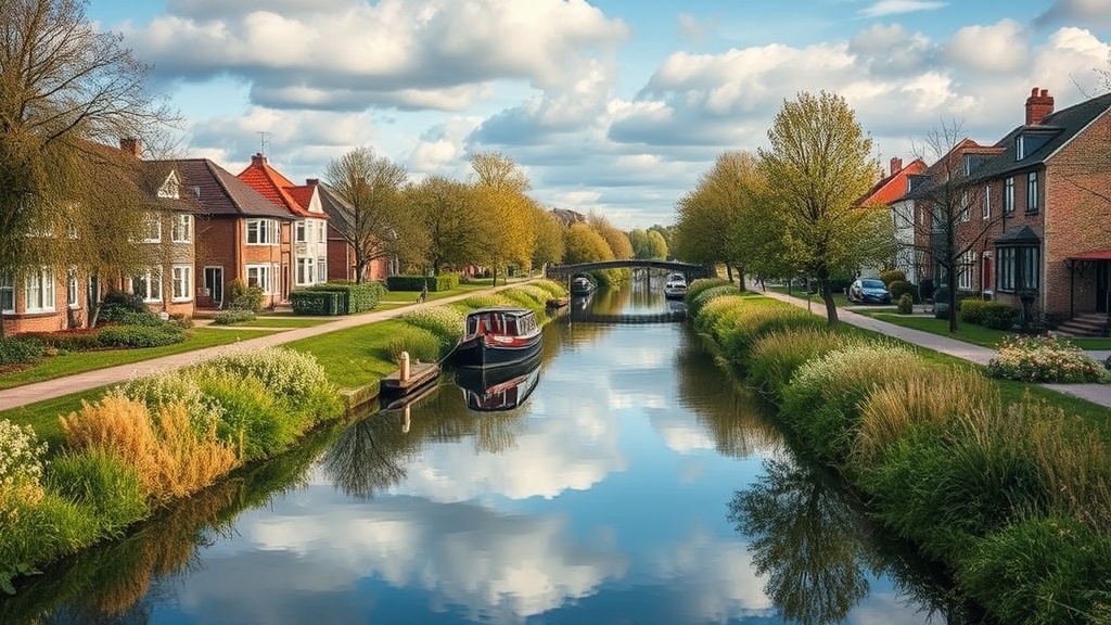
Let's start with the basics. The canal path runs parallel to the historic Chambly Canal, which connects the Richelieu River to the Saint Lawrence River system. For locals, this isn't just a tourist attraction — it's a 14-kilometer linear park that cuts through the heart of our city. The path is paved, well-maintained, and mostly level (perfect for strollers, wheelchairs, and anyone who doesn't want to tackle hills). You'll see cyclists, runners, families, and plenty of regulars who treat this as their daily routine.
Where Are the Best Starting Points for Walking the Chambly Canal?
The most convenient starting points are at Parc des Ateliers, the locks near Rue Martel, and the area behind the Chambly Museum — each offering free parking and immediate access to the main trail. Your choice depends on which part of town you're coming from and how far you want to walk.
Parc des Ateliers (Bassin-de-Chambly area): This is arguably the most popular access point — and for good reason. There's ample parking, clean restrooms (seasonal), and you're right at the wide basin where boats turn around. From here, you can head south toward the old town core or north toward the quieter residential stretches. The path here is widest, making it ideal if you're walking with a group.
Rue Martel Access (near Lock No. 9): This spot puts you right at one of the most photogenic sections — the old stone locks with their wooden gates. Parking is on-street and fills up faster on weekends, but the trade-off is proximity to Parks Canada's historic canal structures. It's a favorite among locals who want their walk to feel less like exercise and more like a history lesson.
Behind the Chambly Museum (Fort Chambly area): If you're combining your walk with other activities, start here. The Fort Chambly parking lot is large and free, and you're steps from both the museum and the trail. Heading south from this point takes you through some of the shadiest sections — welcome relief on hot July afternoons.
Lesser-Known Access Points Worth Checking Out
Beyond the main three, several smaller entry points serve specific neighborhoods. The path behind École secondaire de Chambly connects students and residents to the trail without dealing with traffic. Further north, the access near Rue Pierre-Mercure offers a quieter start — you'll rarely fight for parking here. These secondary spots matter because they let you customize your route rather than following the same out-and-back pattern every time.
What Routes Do Local Residents Actually Walk?
The most common routes are the 3-kilometer loop around the Bassin-de-Chambly, the 5-kilometer stretch from Fort Chambly to the Écluses-de-Chambly, and the full 7-kilometer one-way walk from the basin to the northern trail terminus. Each serves different purposes — quick exercise, a proper workout, or a long morning ramble.
Here's how they compare:
| Route | Distance (one way) | Surface | Best For | Parking |
|---|---|---|---|---|
| Bassin-de-Chambly Loop | 3 km | Asphalt | Quick walks, strollers | Parc des Ateliers |
| Fort Chambly to Écluses | 5 km | Asphalt/gravel mix | Daily exercise | Fort Chambly lot |
| Full northern stretch | 7 km | Mostly asphalt | Long walks, training | Rue Martel or basin |
| Southern residential section | 2.5 km | Asphalt | Dog walking, quiet time | Street parking on Bourgogne |
The Bassin loop remains the community default — you'll see the same faces every morning, usually between 7 and 8 AM. That said, the full northern stretch has its devoted followers. The further north you go, the fewer tourists you'll encounter. By kilometer 5, it's mostly Chambly locals walking their dogs or training for events.
Worth noting: the path officially continues beyond our city limits into Saint-Jean-sur-Richelieu. There's no sign saying "You are now leaving Chambly" — the pavement just keeps going. If you're tracking distance, Strava segments labeled "Canal de Chambly North" or similar cover the whole route. Many residents use these to measure progress or compete informally with friends.
Connecting Routes and Neighborhood Links
One underappreciated feature — the canal path connects to several residential streets via marked pedestrian links. From the trail, you can reach Boulevard de Périgny, Rue Principale, and Avenue Bourgogne without walking on busy roads. These connections matter if you live in the neighborhoods east of the canal. Instead of driving to the basin, you can walk to the path in five minutes.
The link near Rue Martel is particularly useful. It lets you cut through to the commercial strip on Principale — meaning you can walk the canal, grab coffee at one of the local cafés, and walk back without ever using your car. That's the kind of practical integration that makes Chambly's path system actually useful rather than just scenic.
What Should You Know About Seasonal Conditions on the Path?
The path remains usable year-round, but conditions vary significantly — summer brings crowds and limited shade, fall offers the best experience, winter requires proper footwear for ice, and spring often means muddy sections near the locks. Knowing what to expect each season helps you dress appropriately and pick the right segment.
Summer (June-August): The northern sections — especially between Fort Chambly and the first few locks — have mature trees that provide decent shade. The area around the basin? Not so much. You'll want sunscreen, water, and early morning timing if you're walking in July. The path gets busy with tourists on weekends, particularly near the rental boat docks. Weekday mornings remain pleasantly quiet.
Fall (September-October): Here's the thing — this is when the canal path shines. The cottonwoods and maples turn yellow and red, the temperature drops to comfortable walking weather, and the tourist crowds thin out after Labour Day. Local photography groups often schedule walks here in October. The light between 4 and 6 PM is particularly good for photos of the old stone structures.
Winter (November-March): The path stays open unless there's active maintenance. Parks Canada clears some sections, but ice remains an issue — especially on the bridges over the locks. Microspikes or yaktrax-style grips make a significant difference. You'll see dedicated locals out every day, but numbers drop to the committed few. The trade-off? Solitude and views of the frozen canal that summer walkers never experience.
Spring (April-May): This is the messy season. Snowmelt creates puddles, particularly near the lock mechanisms where drainage is poor. The path is technically open, but you'll want waterproof footwear. By late May, conditions normalize — and the greening trees make it worth the wait.
Facilities and Amenities Along the Route
Water fountains appear at roughly 2-kilometer intervals during summer months (typically May through October). Restrooms are available at Parc des Ateliers and Fort Chambly — both maintained reasonably well. Beyond that, you're looking at portable toilets near the main locks or using facilities at businesses along Rue Principale.
Benches are plentiful, especially in the southern sections. If you're walking with elderly family members or someone who needs frequent breaks, plan a route that stays south of the Rue Martel access point. The northern stretch has fewer rest stops.
How Do Residents Combine Walking With Other Local Activities?
The most common combinations are walking plus coffee at a Principale Street café, walking plus a stop at the Chambly Market (seasonal), or walking plus a visit to Fort Chambly's grounds. These pairings turn exercise into a full morning or afternoon.
Here's how locals structure these combinations:
- The "Basin Loop + Coffee" route: Park at Parc des Ateliers, walk the 3-kilometer loop, then head up to Rue Principale via the pedestrian link. Grab coffee, walk back. Total time: 60-75 minutes.
- The "History Walk": Start at Fort Chambly, tour the grounds (free to walk the exterior), then head south on the path to see the lock system up close. Total distance varies based on how far you continue.
- The "Market Morning": During market season (roughly May-October), walk to the basin area, browse the vendors, then continue your walk. The market runs Saturday mornings and brings serious foot traffic — arrive early if you want to park.
- The "Dog Social": The area near the big field south of the basin (between the path and Rue Principale) functions as an unofficial off-leash meeting spot early mornings. Walk there, let your dog socialize, continue your route.
The catch? Timing matters. The path near the market or Fort Chambly gets crowded on weekend mornings. If you're walking for exercise rather than socializing, weekday evenings or early weekend mornings work better.
Safety and Etiquette Reminders
Cyclists share this path — there's no separate bike lane on most sections. The unofficial rule: walkers keep right, faster traffic (runners, cyclists) passes left with a warning. Most cyclists are courteous locals who know the drill, but weekend tourists on rental bikes sometimes forget. Keep dogs leashed — there's a bylaw, and enforcement does patrol occasionally.
After dark, the path is technically open but sparsely lit. The sections near the basin have some lighting; the northern stretches do not. Most residents stick to daylight hours or use headlamps if walking early morning in winter.
One practical note: cell service can be spotty in the section between the third and fourth locks heading north. It's not a dead zone, but calls may drop. If you're walking alone and have safety concerns, stick to the southern sections where coverage is reliable.
The Chambly Canal walking path isn't a destination you visit once for Instagram photos — it's infrastructure our community actually uses. The same people you'll see in July are there in February, just wearing heavier jackets. That consistency is what makes it valuable. You don't need special equipment, you don't need to drive anywhere, and you don't need to plan extensively. You just need shoes and a willingness to step outside.